Maps of
Sonoma County
Map
Databases
~ David
Rumsey Map Collection (Free, can download, and can
buy). . . Link
~ Google Images (everyone knows google by now) . . . Link
~ Historic Map Works (Free to view, though hard to zoom, can purchase) . . . Link
~
Library of Congress,
Digital Collections, Geography and Places (you can
find the Sanborn fire maps here) . . . Link
~ Linkpendium,
Sonoma County, California: Map and Gazetteers (Site
like this, an assortment of maps) . . . Link
~ Newberry:
Map, Travel and Exploration Collections . . . Link
* Atlas of Historical County Boundaries . . . Link
* Mapping Movement in American History and Culture . . . Link
~ USGS: Science for a changing world. Under Maps: Map Releases, Topograpic (Topo) Maps, Volcanic Maps & All Maps. . . Link
Maps
of Sonoma County By Town (or Township)
First line will have: MAP NAME: YEAR, ORIGIN COLLECTION.
Second line has information about the map, mostly what TOWNS / TOWNSHIPS / LOCATION NAMES the map shows.
** I want to make these maps (and other documents) searchable by name, so I will have to transcribe the names found on the maps. I think I will have to put the lists of names on a different page, but I'll work on that. But YOU can help me with this project! Simply go to a map below, carefully type up all the People Names that you can find, and email the list to me with the name of the map through the Queries page. I will gladly give you credit for the submission! And you will have helped others who are doing research!
Analy
Township
Analy, Santa Rosa, Vallejo, and
Petaluma Townships: 1877,
David Rumsey
Collection.
First county atlas of Sonoma County. Thompson published county atlases in Illinois in the early 1870's with Lewis Everts; he came to California in the mid 1870's
Ocean, Bodega, and Analy Townships: 1877, David Rumsey Collection.
Map of the City of Healdsburg, Sonoma Co. Cal. 1877. (with) Santa Rosa Brewery, Santa Rosa, Cal. Joost & Metzger, Proprs. Map Number Seven. (Ocean, Bodega, and Analy Townships.)
Russian River, Santa Rosa, Analy
Townships: 1877,
David Rumsey
Collection.
Historical Atlas Map Of Sonoma County, California. Compiled, Drawn and Published From Personal Examinations and actual Surveys By Thos. H. Thompson & Co. Oakland, Cala. 1877
Salt Point, Ocean, Mendocino,
Redwood, Bodega, and Analy Townships: 1877, David Rumsey Collection.
Plat of Sebastopol. (with) Map of Guerneville. (with) Plat of Bodega Corners. Map Number Three. (Salt Point, Ocean, Mendocino, Redwood, Bodega, and Analy Townships.)
5 N, 9 W, Bloomfield: 1898, David Rumsey Collection.
Col. lithographed map. Relief shown by hachures. Shows Public Land townships and sections, Blucher Rancho, Analy Township, landowners with acreages, Bloomfield, drainage, etc. Inset shows block numbers, owners of large parcels, et
6 N, 8 W: 1898, David Rumsey Collection.
Col. lithographed map. Relief shown by hachures. Shows Public Land townships and sections, ranchos Canada de Jonive, Canada de Pogolimi and Blucher, Bloomfield, Analy Township, landowners with acreages, railroads, drainage, etc.
6 N, 9 W: 1898, David Rumsey Collection.
Col. lithographed map. Relief shown by hachures. Shows Public Land townships and sections, ranchos Llano de Santa Rosa, Roblar de la Miseria and Cotati, Analy and Santa Rosa townships, town of Cotati, landowners with acreages, railroad, drainage, etc.
Bodega Township
6 N, 10 W: 1898,
David Rumsey Collection.
Col. lithographed map. Relief shown by hachures. Shows Public Land townships and sections, ranchos Bodega and Estero Americano, Bodega, Valley Ford, Freestone, Bodega Township, landowners with acreages, railroad, drainage, etc.
6 N, 11 W, Bodega Corners: 1898, David
Rumsey Collection.
Col. lithographed map. Relief shown by hachures. Shows Public Land townships and sections, Bodega Rancho, Bodega Bay, Bodega Port, Duncan Point, Bodega Township, landowners with acreages, drainage, etc
7 N, 10 W: 1898,
David Rumsey Collection.
Col. lithographed map. Relief shown by hachures. Shows Public Land townships and sections, Bodega Rancho, Occidental, Sylvania, Camp Meeker, Russian River Station, landowners with acreages, railroad, drainage, etc.
California
Map
of the States of California and Nevada: 1877,
David Rumsey Collection.
Map of the States of California and
Nevada Carefully Compiled From Actual Surveys, Personal
examinations and information furnished by the County
Surveyors of the State expressly for this Work. Counties
marked by color
Cloverdale Township
Cloverdale, Washington, Mendocino, and
Knight's Valley Townships: 1877,
David Rumsey Collection.
Plat of Cloverdale (with) Map of Pine Flat (both) Sonoma Co, Cal. Map Number Two. (Cloverdale, Washington, Mendocino, and Knight's Valley Townships.)
Salt Point, Mendocino, and Cloverdale
Townships: 1877,
David Rumsey Collection.
Map of Occidental (with) Plan of Geyserville. (both) Sonoma Co. California, 1877. Map Number One. (Salt Point, Mendocino, and Cloverdale Townships.)
11-12 N, 9 W: 1898, David Rumsey Collection.
Col. lithographed map. Relief shown by hachures. Shows Public Land townships and sections, Rancho Caslamayomi, part of Cloverdale Township, Geysers, Geyser Peak, landowners with acreages, drainage, etc. Covers only part of T. 12 N., R. 9 W.
11-12 N, 10 W: 1898, David Rumsey Collection.
Col. lithographed map. Relief shown by hachures. Shows Public Land townships and sections, Rancho Musalacon, Rancho Caslamayomi, Cloverdale, Asti, Cloverdale Township, landowners with acreages, railroad, drainage, etc. Covers only a portion of T. 12 N., R. 10 W.
11 N, 11 W: 1898,
David Rumsey Collection.
Col. lithographed map. Relief shown by hachures. Shows Public Land townships and sections, part of Rancho Musalacon, landowners with acreages, part of Cloverdale Township, drainage, etc.
Cloverdale: 1898, David Rumsey Collection.
Col. lithographed map. Shows block
and lot numbers, tracts, large parcel landowners,
railroad, drainage, etc.
Duncan Slough
3 N, 6 W: 1898,
David Rumsey Collection.
Col. lithographed map. Relief shown by hachures. Shows Public Land townships and sections, landowners with acreages, Duncan Slough, Petaluma Point, railroads, drainage, etc.
Forestville
10 N, 15 W, Forestville, Guerneville,
Valley Ford: 1898,
David Rumsey Collection.
T 10 N., R. 15 W. (with) Forestville.
(with) Guerneville. (with) Valley Ford. (Published by
Reynolds & Proctor, Santa Rosa, Cal., 1898) German
Rancho
Fort Ross
Carte Detaillee Du Mouillage Du Fort Ross: 1844, David
Rumsey Collection.
Map details the region of northern California under the control of the Russians, from Bodega Bay to Fort Ross in the north.
8 N, 12 W: 1898,
David Rumsey Collection.
Col. lithographed map. Relief shown by hachures. Shows Public Land townships and sections, Muniz Rancho, Fort Ross, Creighton Ridge district school, Sea View P.O., landowners with acreages, etc.
San Andreas Rift near Fort Ross: 1908, David
Rumsey Map Collection.
Detail map of a typical portion of the San Andreas Rift near Fort Ross, Sonoma County, California showing its geomorphic features and the trace of the fault by Francois E. Matthes.
Geysers (Geyserville)
11 N, 8 W: 1898, David Rumsey Collection.
Col. lithographed map. Relief shown by hachures. Shows Public Land townships and sections, landowners with acreages, Little Geysers, Socrates Mine, drainage, etc.
11 N, 15 W; Geyserville: 1898,
David Rumsey Collection.
Col. lithographed map. Relief shown by hachures. Shows Public Land townships and sections, land grants, landowners with acreages, settlements, drainage, etc.
Glen Ellen
Sonoma, Glen Ellen: 1898, David Rumsey Collection.
Col. lithographed map. Shows lot numbers, railroad, owners of large parcels, etc. Glen Ellen, at 1:9,600, shows block and lot numbers, tracts, owners of large parcels, etc.
Healdsburg
Bird's eye view of Healdsburg, Cal: c1876, American Memory from the Library of Congress.
Healdsburg and Russian River Valley: c1876, Bird's Eye View: c1876, Ancestry.com.
A Searchable Index: Reimann House,
Windsor, H.G. Reimann, proprietor. Emory Stable and Meat
Market, Windsor. Dr. H.S. Hewitt, Healdsburg, Cal. Fulton
Winery, property of Fulton Winery Corporation.
Healdsburg, Cal: 1898,
David Rumsey Collection.
Healdsburg, Sonoma Co., Cal. ; Col. lithographed map. Shows block and lot numbers, tracts, owners of large parcels, railroad, drainage, etc.
Kenwood
7 N, 6 W: 1898,
David Rumsey Collection.
Col. lithographed map. Relief shown by hachures. Shows Public Land townships and sections, Rancho Los Guilicos, Kenwood, Mount Hood, landowners with acreages, railroads, drainage, etc.
Knights Valley Township
"Fossville" Res of Clark Foss, Knights Valley, Sonoma County, California: 1877, David Rumsey Collection.
"Fossville" Res of Clark Foss, Knights Valley, Sonoma County, California. Mt. Saint Helena. Historical Atlas Map Of Sonoma County, California. Compiled, Drawn and Published From Personal Examinations and actual Surveys By Thos. H. Thompson & Co. Oakland, Cala. 1877.
Mendocino, Russian River, Knights Valley, Santa Rosa Townships: 1877, David Rumsey Collection.
Map Number Four. (Mendocino, Russian River, Knights Valley, Santa Rosa Townships.)
9 N, 7 W: 1898, David Rumsey Collection.
Col. lithographed map. Relief shown by hachures. Shows Public Land townships and sections, Mallacomes Rancho, Knights Valley Township, Kellogg, landowners with acreages, drainage, etc.
9 N, 8 W: 1898, David Rumsey Collection.
Col. lithographed map. Relief shown by hachures. Shows Public Land townships and sections, Sotoyome and Mallacomes ranchos, Knights Valley and Russian River townships, Maacama district school, landowners with acreages, drainage, etc.
10 N, 8 W: 1898,
David Rumsey Collection.
Col. lithographed map. Relief shown by hachures. Shows Public Land townships and sections, landowners with acreages, drainage, Knights Valley Township, Pine Flat and Double Pine district schools, etc.
Mendocino Township
3 N, 5 W: 1898,
David Rumsey Collection.
Col. lithographed map. Relief shown by hachures. Shows Public Land townships and sections, landowners with acreages, railroad, Midshipmans Slough, drainage, etc.
8 N, 9 W: 1898,
David Rumsey Collection.
Col. lithographed map. Relief shown by hachures. Shows Public Land townships and sections, Sotoyome and El Molino ranchos, Mendocino and Russian River townships, West Windsor, East Windsor, landowners with acreages, railroad, drainage, etc.
9 N, 9 W: 1898,
David Rumsey Collection.
Col. lithographed map. Relief shown by hachures. Shows Public Land townships and sections, landowners with acreages, Healdsburg, Lytton, Sotoyome Rancho, railroad, drainage, etc.
9 N., 10 W: 1898,
David Rumsey Collection.
Col. lithographed map. Relief shown by hachures. Shows Public Land townships and sections, Sotoyome Rancho, landowners with acreages, Davis and Grape district schools, Mendocino Township, drainage, etc.
9 N., 11 W: 1898,
David Rumsey Collection.
Col. lithographed map. Relief shown by hachures. Shows Public Land townships and sections, landowners with acreages, Mendocino Township, Austin Creek district school, drainage, etc.
10 N, 10 W: 1898,
David Rumsey Map Collection.
Col. lithographed map. Relief shown by hachures. Shows Public Land townships and sections, Tzabaco Rancho, Mendocino Township, landowners with acreages, railroad, drainage, etc.
10 N, 11 W: 1898,
David Rumsey Collection.
Col. lithographed map. Relief shown by hachures. Shows Public Land townships and sections, landowners with acreages, Skaggs Springs, present-day Lake Sonoma, part of Mendocino Township, drainage, etc.
10 N, 12 W: 1898,
David Rumsey Collection.
Col. lithographed map. Relief shown by hachures and spot heights. Shows Public Land townships and sections, landowners with acreages, part of Mendocino Township, drainage, etc
11 N, 12 W: 1898,
David Rumsey Collection.
Col. lithographed map. Relief shown by hachures. Shows Public Land townships and sections, landowners with acreages, drainage, etc. Covers part of Mendocino Township.
11 N, 13 W: 1898,
David Rumsey Collection.
Col. lithographed map. Relief shown by hachures. Shows Public Land townships and sections, landowners with acreages, drainage, etc. Covers part of Mendocino Township.
Occidental
10 N, 7 W; Occidental: 1898, David Rumsey Collection.
Col. lithographed map. Relief shown by hachures and spot heights. Shows Public Land townships and sections, landowners with acreages, drainage, Mount Saint Helena, etc. Occidental
Ocean
Township
7 N, 11 W: 1898,
David Rumsey Collection.
Col. lithographed map. Relief shown by hachures. Shows Public Land townships and sections, Bodega and Muniz ranchos, Ocean Township, Duncan's Mills landowners with acreages, railroads, drainage, etc.
Petaluma
Map of Petaluma City: 1877,
David Rumsey Collection.
Map in color by area. Map is numbered with an accompanying explanation.
City of Petaluma, Sonoma County,
California: 1938,
David Rumsey Collection.
Title is from the cover. There is no title page. Date is estimated. 1st "road" atlas of California.
Petaluma
Township
Historic Topographic Maps of California: Berkley Library.
Searchable Database: Petaluma is only
Sonoma County City found.
Petaluma and Vallejo Townships: 1877, David
Rumsey Collection.
Cypress Hill Cemetery, Petaluma. Map Number Eleven. (Petaluma and Vallejo Townships.)
Petaluma, Vallejo, and Sonoma Townships: 1877, David
Rumsey Collection.
Map Number Ten. (Petaluma, Vallejo, and Sonoma Townships.) In full color. Map includes the bottom section of the city of Sonoma.
4 N, 7 W: 1898,
David Rumsey Collection.
Col. lithographed map. Relief shown by hachures. Shows Public Land townships and sections, Petaluma, Petaluma Township, landowners with acreages, railroad, drainage, etc.
4 N, 8 W: 1898,
David Rumsey Collection.
Col. lithographed map. Relief shown by hachures. Shows Public Land townships and sections, Rancho Laguna de San Antonio, Petaluma Township, landowners with acreages, drainage, etc.
5 N, 8 W: 1898,
David Rumsey Collection.
Col. lithographed map. Relief shown by hachures. Shows Ranchos Blucher, Roblar de la Miseria, Cotate and Laguna de San Antonio, landowners with acreages, Stony Point, Petaluma Township, railroad, drainage, etc.
Petaluma: 1898,
David Rumsey Collection.
Col. lithographed map. Shows tracts, lot numbers, railroad, reservoir, etc. Petaluma, Sonoma Co., Cal. (Published by Reynolds & Proctor, Santa Rosa, Cal., 1898)
Redwood Township
8 N, 10 W:
1898, David
Rumsey Collection.
Col. lithographed map. Relief shown by hachures. Shows Public Land townships and sections, Sotoyome Rancho, Redwood Township, Guerneville, Korbell Station, landowners with acreages, railroad, drainage, etc.
8 N, 11 W: 1898,
David Rumsey Collection.
Col. lithographed map. Relief shown by hachures and spot heights Shows Public Land townships and sections, Redwood and Ocean townships, Mount Ross, Cazadero, Kidd Creek, Montgomery and Madrona district schools, landowners with acreages, railroad, drainage, etc.
Russian River Township
8 N, 8 W: 1898, David Rumsey Collection.
Col. lithographed map. Relief shown by hachures. Shows Public Land townships and sections, landowners with acreages, Fulton, Mark West, Mark West Springs, Russian River and Santa Rosa townships, railroad, drainage, etc.
Salt Point Township
8 N, 13 W: 1898,
David Rumsey Collection.
Col. lithographed map. Relief shown by hachures. Shows Public Land townships and sections, German and Muniz ranchos, Fort Ross, Salt Point, Gerstler Cove, Timber Cove, landowners with acreages, drainage, etc. Duncans Mills
9 N, 12 W: 1898,
David Rumsey Collection.
Col. lithographed map. Relief shown by hachures. Shows Public Land townships and sections, landowners with acreages, settlements, drainage, Table Mountain district school, etc.
9 N, 13 W: 1898,
David Rumsey Collection.
Col. lithographed map. Relief shown by hachures. Shows Public Land townships and sections, German Rancho, Salt Point township, landowners with acreages, Gualala, Fisk's Mill and Dirigo district schools, drainage, etc.
9 N, 14 W: 1898,
David Rumsey Collection.
Col. lithographed map. Relief shown by hachures. Shows Public Land township and sections, German Rancho, Stewart's Point, Fisherman Bay, Horse Shoe Bay, landowners with acreages, drainage, etc.
10 N, 13 W: 1898,
David Rumsey Collection.
Col. lithographed map. Relief shown by hachures. Shows Public Land townships and sections, part of Salt Point Township, landowners with acreages, drainage, etc.
10 N, 14 W: 1898,
David Rumsey Collection.
Col. lithographed map. Relief shown by hachures. Shows Public Land townships and sections, German Rancho, Salt Point Township, Black Point, railroad, landowners with acreages, drainage, etc.
11 N, 14 W: 1898,
David Rumsey Collection.
Col. lithographed map. Relief shown by hachures. Shows Public Land townships and sections, landowners with acreages, drainage, etc. Rock Pile Creek, California Redwood Land Lumber Co.
Santa Rosa
Bird's eye view of Santa Rosa, Sonoma County, Cal: 1876, American Memory from the Library of Congress.
Map of The City of Santa Rosa: 1876, David
Rumsey Collection.
Santa Rosa city map includes numbered buildings with an accompanying key. Both maps in full color. View uncolored and with text below map reading, "The Times is a first class local republican journal. Geo H. Marr, Editor & Proprietor. Terms $3.00 per annum." Through the window can be seen men working on the paper.
Mendocino, Russian River, Knights Valley,
Santa Rosa Townships: 1877,
David Rumsey Collection.
Map Number Four. (Mendocino, Russian River, Knights Valley, Santa Rosa Townships.)
Santa Rosa and Sonoma Townships: 1877, David
Rumsey Collection.
Map in full color. Views on facing page, without color. The Armstrong's Villa Plats are numbered. The City Stables proprietor is H.W. Byington. Plat of Windsor (with) Plat of Town of Fulton. Map Number Five. (Santa Rosa and Sonoma Townships.) (facing page) View of J.B. Armstrong's Villa Plats, at Norwood, adjoining the City of Santa Rosa. (with) City Stables, Santa Rosa. (with) Hinds' Hotel, Freestone. (with) "Oak Wood Villa," Res. of Mrs. Dr. Barrett, Healdsburg. (with) Res. of J.J. Wheeler, Santa Rosa. (with) Res. of Mary Brooks, Russian River Tp. (all) Sonoma County, Cal.
Santa Rosa, Vallejo, and Sonoma Townships: 1877, David
Rumsey Collection.
In full color. Map of Sonoma shows numbered buildings with an associated key. Map of Sonoma City, Sonoma Co. Cal. 1877. Map Number Nine. (Santa Rosa, Vallejo, and Sonoma Townships.)
Map of The City Of Santa Rosa And Vicinity: 1896, David
Rumsey Collection.
Scarce, detailed map of Santa Rosa showing the rapid subdivision growth at the turn of the century. Not in any references. With an inset map of "The Relative Position of Santa Rosa To The Bay of San Francisco..." of which a portion is missing. Two smaller inset maps are titled: "Plat of Bogart's Sub's ..." and "Plat showing Portion Of City Covered By Fire Limits." In printed color, on thin paper. Portions of this map appear, with credit to Smyth, in Reynolds and Proctor's "Illustrated Atlas of Sonoma County," 1898 (see our copy). Full color.
6 N, 7 W: 1898,
David Rumsey Collection.
Col. lithographed map. Relief shown by hachures. Shows Public Land townships and sections, Rancho Cotati, Santa Rosa and Vallejo townships, Strawberry, Steuben, Copeland and Burns district schools, landowners with acreages, railroad, drainage, etc.
7 N, 7 W: 1898,
David Rumsey Collection.
Col. lithographed map. Relief shown by hachures. Shows Public Land townships and sections, ranchos Cabeza de Santa Rosa and Los Guilicos, Melita, Annadel, Volupa Peak, Santa Rosa Water Works, landowners with acreages, railroad, drainage, etc.
7 N, 8 W: 1898,
David Rumsey Collection.
Col. lithographed map. Relief shown by hachures. Shows Public Land townships and sections, Santa Rosa, ranchos San Miguel, Llano de Santa Rosa, Cabeza de Santa Rosa, landowners with acreages, railroad, drainage, etc.
7 N, 12 W; Kenwood, Rincon Heights: 1898, David Rumsey Collection.
Col. lithographed
map. Relief shown by hachures. Shows Public Land townships and
sections, Rancho Muniz, Ocean Township, Russian Gulch,
landowners with acreages, drainage, etc. Inset maps show lot
numbers, streets, railroad, etc. Rincon Heights located at
conjunction of Santa Rosa and Rincon creeks, Santa Rosa.
8 N, 7 W: 1898,
David Rumsey Collection.
Col. lithographed map. Relief shown by hachures. Shows Public Land townships and sections, landowners with acreages, Alpine, Porter Creek, Goodman and Pine Mountain district schools, drainage, etc.
Santa Rosa: 1898,
David Rumsey Collection.
Col. lithographed map. Shows tracts, lot numbers, owners of large parcels, railroad, etc.
Sebastopol
7 N, 9 W: 1898,
David Rumsey Collection.
Col. lithographed map. Relief shown by hachures. Shows Public Land townships and sections, ranchos Canada de Jonive and Molino, Sebastopol, Forestville, landowners with acreages, railroads, drainage, etc.
Sebastopol: 1898,
David Rumsey Collection.
Col. lithographed map. Shows tracts,
lot numbers, owners of large parcels, railroads, etc.
Sonoma County General
Plan and profile of State highway in Sonoma County: Internet Archive.
Between 2.0 miles north and 0.7 mile south of Santa Rosa, Sheets 1-19
Sonoma County Gazetteer: USGS Geographic Names Information System.
Sonoma County Post Offices: A List of Post offices.
Sonoma County Postal
Covers: A List of Postal Covers?
Sonoma County Sanborn
Maps: The Library of
Congress.
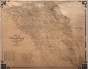
Bowers, A.B. Map Of Sonoma County Ca:
1866, David
Rumsey Collection.
First edition, not listed by Vodges - he lists the 1867 second edition, see our 4222.000. With four inset maps of towns. This is the earliest wall map of Sonoma County that we have seen.
Map of Sonoma County California. Thompson: 1877, David
Rumsey Collection.
In color by region. The Sonoma Democrat is in Santa Rosa. Thos L. Thompson is the proprietor. R.A. & T.L. Thompson are the editors. The McCunes Block building is the office of the Petaluma Weekly Argus, established Aug. 1855. Weston, Scunder & Co., Proprietors. Petaluma, Ca.
Sonoma County California, Thompson: 1877, Maps of the Past.
Original Townships of: Cloverdale, Petaluma, Salt Point, Vallejo, Mendocino, Sonoma, Washington, Knights Valley, Russian river, Ocean, Redwood, Santa Rosa, Cranes Peak, Black Mountain, Bennet Peak, Sonoma Valley, Bennet Valley, Duncan Mills, Dry Creek, Big Sulphur Creek, Russian River, False Bay, San Antonio Creek, School Houses Located & Forestville Post Office.
Sonoma County California 1877: 1877, Historic Map Work.
Collection: California, Sonoma County 1877; Thos. H. Thompson & Co., 1877. Has four Categories: MAPS; Directories; History & Illustrations. Everything is Black & White. Image Quality: Informational quality scan which is suitable for research use and lends itself nicely to being reproduced in our research print format.
Sonoma County Land Ownership Atlas: 1877, Ancestry.com.
Searchable Database: Land ownership maps are portrayals of land purchased, granted, or inherited. They range in complexity from rough outlines of the boundaries of one tract of land to detailed county atlases showing every landowner at the time of compilation. Has black and white imdd images to go with entries.
Sonoma, Marin, Lake, and Napa Counties
- Bike Paths: 1896,
David Rumsey Collection.
Bike paths shown in red and labeled with abbreviations.
Sonoma Coounty, Calif.: 1898,
David Rumsey Collection.
Map of Sonoma County, California. 1898. (Published by Reynolds & Proctor, Santa Rosa, Cal., 1898) Col. lithographed map. Relief shown by hachures. Shows political townships (in full color) , U.S. Public Land townships and sections, land grants, settlements, railroads, drainage, etc. Includes index to towns.
Sonoma County 1898: 1898,
Historic Map Work.
Search and put as separate maps
Official Map of Sonoma County, California: 1900, David
Rumsey Collection.
Highly detailed map showing virtually all landowners, railroads, ranchos, as well as topography. Official Map of Sonoma County, California Compiled From The Official Maps In The County Assessor's Office, With Additions And Corrections To June 1st 1900 by L.E. Ricksecker, City Engineer Of Santa Rosa, Ex-County Surveyor, and W.B. Walkup, Publisher. Approved and declared to be the official map of Sonoma County, by resolution of the Board of Supervisors, September 7th 1900 ... Copyrighted Sept. 1900 By W.B. Walkup. (one sheet of four only, upper right sheet with title showing the northwestern portions of the county).
Sonoma County 1900 Wall Map: 1900, Historic Map Work.
Sonoma County, Santa Fe Railroad: 1900, David
Rumsey Collection.
Blue print map of northern California up to the Sierra Nevada. This was probably an internal planning map for the Santa Fe Railroad, showing four different railroad routes from the east Bay and Sonoma County north to Humbolt County. Also shows towns, railroads, townships, wagon roads, unsurveyed lands, mountains and the Redwood Belt. This map came from the archive of the Santa Fe Railroad.
Sonoma County 1907: 1907,
Historic Map Work.
Sonoma County c1940: 1940, Historic Map Work.
Sonoma County 1957: 1957, Historic Map Work.
Sonoma County county-wide thoroughfares plan report: 1959, Internet Archive.
Sonoma County c1975: 1975, Historic Map Work.
Sonoma County 1980 to 1996: 1980-1996, Historic Map Work.
Individual County Chronologies: 2003, The Newberry Library.
California: Individual
County Chronologies.: California
Atlas of Historical County Boundaries.
Sonoma Township
4 N, 5 W: 1898,
David Rumsey Collection.
Col. lithographed map. Relief shown by hachures. Shows Public Land townships and sections, Sears Point, McGills, Sonoma and Vallejo townships, landowners with acreages, railroads, drainage, etc.
5 N, 5 W: 1898,
David Rumsey Collection.
Col. lithographed map. Relief shown by hachures. Shows Rancho Huichica, Sonoma, Schellville, San Luis, Sonoma Township, landowners with acreages, railroad, drainage, etc.
6 N, 5 W; Agua Caliente: 1898,
David Rumsey Collection.
Col. lithographed map. Relief shown by hachures. Shows Public Land townships and sections, Sonoma Township, landowners with acreages, drainage, etc.
6 N, 6 W: 1898,
David Rumsey Collection.
Col. lithographed map. Relief shown by hachures and spot heights. Shows Public Land townships and sections, ranchos Los Guilicos, Petaluma and Agua Caliente, Kenwood, Glen Ellen, Agua Caliente, Gelston, Eldridge, State Home for the Feeble, Sonoma Mountain, landowners with acreages, railroad, drainage, etc.
Vallejo Township
4 N, 6 W: 1898, David Rumsey Collection.
Col. lithographed map. Relief shown by hachures. Shows Public Land townships and sections, Rancho Petaluma, Vallejo Township, Lakeview, Donahue, Hog Island, landowners with acreages, railroad, drainage, etc.
5 N, 6 W: 1898,
David Rumsey Collection.
Col. lithographed map. Relief shown by hachures. Shows Petaluma Rancho, Vallejo Township, El Verano, Sonoma, landowners with acreages, railroad, drainage, etc.
5 N, 7 W: 1898,
David Rumsey Collection.
Col. lithographed map. Relief shown by hachures. Shows Petaluma, Penns Grove, Ely, Corona, Vallejo Township, ranchos Cotate and Petaluma, landowners with acreages, railroad, drainage, etc.
10 N, 9 W: 1898,
David Rumsey Collection.
Col. lithographed map. Relief shown by hachures. Shows Public Land townships and sections, Caslamayomi, Sotoyome and Tzabaco ranchos, landowners with acreages, Washington township, Geyserville, railroad, drainage, etc.
Windsor
8 N, 6 W; Windsor, El Verano: 1898, David
Rumsey Collection.
T. 8 N., R. 6 W. (with) West Windsor.
(with) East Windsor. (with) El Verano. (Published by
Reynolds & Proctor, Santa Rosa, Cal., 1898). Col.
lithographed map. Relief shown by hachures. Shows Public
Land townships and sections, landowners with acreages,
drainage, etc. Inset maps show lot numbers, owners of
large parcels, etc.