The Town of Cotati
- Genealogy
- History of Cotati
- The Town Today
- Places of Interest
- People of Interest
Table of Contents
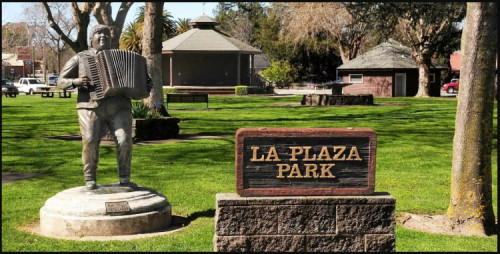
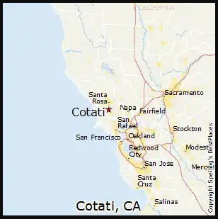
Cotati (/koʊˈtɑːtiː/; Miwok: Kota’ti) is an incorporated city in Sonoma County, California, United States, located approximately 45 mi (70 km) north of San Francisco in the 101 corridor between Rohnert Park and Petaluma. Cotati's population as of the 2020 Census was 7,584, making it the smallest incorporated community in Sonoma County. Like all of Sonoma County, Cotati is included in both the San Francisco Bay Area and North Coast. Located in the Sonoma Coast American Viticultural Area, Cotati can also be considered part of Wine Country. E & J Gallo Winery operates a 400-acre (160 ha) vineyard called Two Rock Vineyard in the hills west of town. Cotati's hexagonal downtown plaza, one of only two hexagonal town layouts in the United States, is California Historical Landmark number 879. The other U.S. city with a hexagonal layout is Detroit, Michigan. [1]
Genealogy
Gedcom Index for Cotati, CA. . . . Link
Surnames: Florer
GenealogyOnline:
About the Town Cotati .
. . Link
Surnames: Buckley, Cassidy, Rostov
Roadside Thoughts: Cotati California . . . Link
Sonoma County Genealogical Society . . . Link
The web site "The Cockrill Family of Sonoma County" [Link] has a wonderful collection of
local genealogy including the following with ties to this
town: Thomas Hopper
History of Cotati
The Coast Miwok civilization thrived in the Cotati area since at least 2000 BC, with principal villages built near major streams. Documented villages in the area included Lumen-takala (northeast of present-day Cotati), Payinecha (west of present-day Cotati), and Kotati. In 1827, an Irishman named John Thomas Reed ventured into Miwok territory and built a cabin near Crane Creek. After the natives burned it, he retreated south to Mill Valley. [1]
In July 1844, the Mexican government granted Rancho Cotate (encompassing present-day towns of Cotati, Penngrove and Rohnert Park, and home to Coast Miwok people) to Captain Juan Castaneda, a Mexican military commander from Texas, in payment for his service as a soldier under General Vallejo. The grant took its name from the Coast Miwok village of Kotati. However, a legend arose that Rancho Cotate was named after a Pomo chief named Cotati, and in 1973 the state perpetuated this legend on the historical marker it placed in the plaza. Rancho Cotate consisted of 17,238.6 acres (6,976.2 ha). Captain Castaneda moved to San Francisco and never developed Rancho Cotate. Because he failed to fulfill the legal requirements of the grant, he lost control of the rancho, which passed to Thomas Larkin and then to Joseph Ruckle. In 1849, Ruckle sold the land to Dr. Thomas Stokes Page, a former resident of Valparaíso, Chile, for $1,600. The landholding remained in the Page family for over eighty years. [1]
The landholding remained in the Page family for over eighty years. Subject to seasonal flooding from the Laguna de Santa Rosa, the land was used to graze cattle and sheep. In October 1870, the San Francisco and North Pacific Railroad completed the first railroad from Petaluma to Santa Rosa, and a town formed around the wood and water stop called Page's Station, then Cotati. [1]
The Cotati area was shaken up by the 1906 San Francisco earthquake. After the quake, Drury Butler reported that "the chimneys were as a rule thrown down". In particular, the Stony Point School at 38.34325°N 122.74166°W suffered a chimney failure. The Northwestern Pacific Railroad built the Cotati Depot in 1907. It was located near the East Cotati Avenue crossing, almost 1 mi (1.6 km) east of the plaza. It was demolished to make way for Sonoma–Marin Area Rail Transit's Cotati station. [1]
Cotati
In 1849, Thomas Page
purchased Rancho Cotate which he controlled until 1929.
Two of the seven Page sons developed the land for cattle
and sheep use and it remained unchanged until the 1890's.
Not until 1892 would a town begin to gather around the
wood and water stop known only as Page's Station, because
when Dr. Page died in 1872, he provided in his will that
the ranch would not be subdivided and sold until the
youngest Page son reached the age of 25. In this way,
Cotati became the last of the Sonoma County Ranchos to
remain intact. Finally, in 1892, the Cotati Land Company
was formed by the Page family to subdivide and sell the
vast ranch, and to transform Page's Station into a small
town. To head up the marketing of the five, ten and twenty
acre parcels, they hired David W. Batchelor, who sold over
900 tracts of land for them. On Feb. 13, 1894 the first
Post Office opened and by the turn of the century Page's
Station had become a town named Cotati. By 1911, the town
could boast that a thousand people had celebrated the
Fourth of July there. Around the Plaza businesses sprang
up, including the Cotati Hotel. . . . [Archived Website. Link]
Cotati School House . . . Link
In February 1921, the old schoolhouse at 201 West Sierra burned down. A new school built on the same site opened in 1922. This building has served as City Hall since 1971. The rear of this building housed the Cotati Police Department until September 3, 2003, when the department moved into a new building next door. [1]
History of Cotati (City Page) .
. . Link
Historical Society . . . Link . . . Official City Page
"The interwoven history of Cotati and Rohnert Park" [Article & 24 images] . . . Link
LocalWiki: Sonoma Valley History. . . Link (Sonoma Valley)
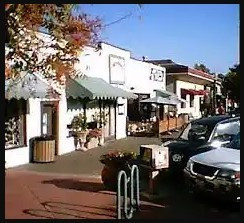
The Town Today
American Towns . . . Link
Cotati Accordion Festival . . . Link
Cotati
Chamber of Commerce . . . Link
"Cotati is still making history" [Article] . . . Link
Cotati Today [Niche] (has a map of location) . . . Link
Sonoma County Life Opens Up: Cotati . . . Link
Town Homepage . . . Link . . . County Page . . . Link
Wikipedia Page: Cotati . . . Link
WikiVoyage: Cotati. . . Link
Places of Interest
Cotati Historical Society Walking Tour Video . . . Link
Please enjoy a short virtual walking tour of historic Cotati, CA, presented by the Cotati Historical Society and the Cotati Chamber of Commerce.
People of Interest
Dr. Thomas Page . . . Link . . .
Dr. Thomas Page's barn once stood where the [Cotati] plaza is today, and each of the streets surrounding the plaza is named after one of his sons. In 1892, the Page family created the Cotati Land Company to subdivide their ranch into parcels of five to twenty acres (two to eight hectares). By 1901, good land was selling for $30 to $60 per acre. Page family ownership ended in 1944. [1]
Newton Smyth . . . Link
Cotati's hexagonal town plan, one of only two such in the United States, was designed during the 1890s by Newton Smyth as an alternative to the traditional grid. [1]
Paul Golis (Rhonert Park) . . . Link
Waldo Emerson Rhonert . . . Link
Bought the Cotati Rancho in 1929 and became established with the C.D. Morse Company, the largest seed-growing farm in the West.
Maps
Map of Cotati, with boundaries
[BingMaps] . . . Link
Map of Cotati [MapQuest] . . . Link
Photos
CaliSphere Cotati Collection . . . Link
Citations
[1]
Wikipedia contributors. "Cotati,
California." Wikipedia, The Free Encyclopedia.
Wikipedia, The Free Encyclopedia, 22 Aug. 2022. Web. 23 Aug.
2022. Viewed 22 Aug. 2022 . . . Link
[2] "Historical and Descriptive Sketch Book of Napa, Sonoma, Lake, and Mendocino: Comprising Sketches of Their Topography, Productions, History, Scenery, and Peculiar Attractions", C.A. Menefee, 1873 . . . Link
[4]
"History of Sonoma County: Including Its Geology,
Topography, Mountains, Valleys and Streams". United
States, Higginson Book Company, 1880. (page
205.) . . . Link .
. . Text at CAGenWeb
[5] "An Illustrated History of Sonoma County, California: Containing a History of the County of Sonoma from the Earliest Period of Its Occupancy to the Present Time", Lewis Publishing, 1889 . . . Link
"The interwoven history of Cotati and Rohnert Park", by Janet Balicki. Santa Rosa Press Democrat. 2016-10-20. Retrieved 2022-08-23. . . . Link